If you weren’t intending to do a survey, but saw something worth recording, then this is best logged as an Incidental survey. This could be an unusual number of birds, an unusual species, or a bird bird you know well showing up in an unusual or unexpected location.
Remember if you are seeing something unusual, particularly a bird that is out of range, provide as much information in the Comments box as you can on what you saw. This can include how you identified the bird and how you eliminated similar species.
Bird lists are simply the list of bird species observed at a location. This survey type has limited scientific value as they are not standardised in duration or area surveyed, preventing useful comparisons between surveys. These lists can be used for recreational purposes regarding the general occurrence of bird species.
This involves searching for birds in a two-hectare area for 20 minutes. The recommended shape for the two hectares is 100 m x 200 metres. You can use other shapes, such as a circle with a radius of 80 metres, or a strip 400 m long x 50 m wide. Only record birds within the two-hectare area (though see Embedded Survey below). Birds flying over the search area should be included.
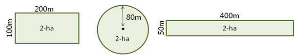
Choosing a 2-ha search area
Do not automatically choose a site which yields the most birds. On occasion choose a site where birds may not be as prevalent. This provides us with a good cross-section of data.
Try to introduce a degree of randomness into your site selection. A good way to do this is to choose a site on a map before you arrive so your choice will not be influenced by the surroundings. You could also randomly choose from sites with similar habitat and management conditions.
Your site should be representative of the particular habitat you are surveying. As much as possible, avoid mixing habitat types (e.g. half grassland/half forest, or half grazed/half ungrazed) in the same 2-ha search area. If you are surveying two nearby 2-ha areas on the same day make sure that the centre of the two areas are at least 400 metres apart, so there is no overlap between them.

If you intend to conduct repeat seasonal surveys in the same 2-ha search area, we would like you to fill out an Atlas habitat form (Habitat Form). These optional forms are issued on request. If a major change occurs at the site, such as a large fire or clearing, a new Habitat Form should be completed. After you complete this form, we will give you a site number for that particular 2-ha search area. You can use this number for each survey at this site to save you time when submitting your results.
The Area Search is more flexible than the 2-ha search — you can search any area, listing the birds seen around a central point. You may do a small Area Search, within 500 metres of a central point, or a larger one that extends beyond 500 metres but is within 5 kilometres of a central point (you must indicate which size of area you searched when submitting your results). The search area can be any shape. Search for at least 20 minutes, but not more than one week, though you may submit calendar-monthly lists by submitting 12 lists per year, one for each calendar month (this is primarily for people who survey a site continuously).
Wetland sites
The Area Search method is usually appropriate for surveying wetland sites. You can survey the whole of a wetland if it remains within 5 kilometres of a central point. This method is also useful for conducting seabird surveys, or producing a bird inventory for small islands.
Embedded surveys combine a 2-hectare/20 minute Search and 500-metre Area Search. Begin with a 2-ha, 20 min survey around a central point and extend the search after 20 minutes to a 500m Area Search. Birds observed outside of the 2-ha area in the first 20 minutes must be noted separately to the 2-ha, 20min search observations. Birds should not be double counted.
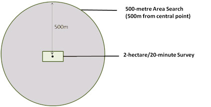
Recording an Embedded Survey
When recording observations from an embedded survey, birds recorded within the 2-ha, 20 min survey should be recorded separately to birds outside of the 2-ha area (without double counting). The data entry system will automatically sum counts within and outside the 2-ha area to calculate the 500 m Area Search totals (see example below).
Entering embedded surveys in Birdata web portal*
Recording embedded surveys in Birdata separates the 2-hectare/20-minute Search + 500-metre Area Search Surveys. Birdata will automatically combine the 2- ha, 20 min observations and outside 2-ha observations to determine the 500 m Area survey totals.
*Embedded Survey not available in the Birdata app

The Area Search is more flexible than the 2-ha search — you can search any area, listing the birds seen around a central point. You may do a small Area Search, within 500 metres of a central point, or a larger one that extends beyond 500 metres but is within 5 kilometres of a central point (you must indicate which size of area you searched when submitting your results). The search area can be any shape. Search for at least 20 minutes, but not more than one week, though you may submit calendar-monthly lists by submitting 12 lists per year, one for each calendar month (this is primarily for people who survey a site continuously).
Wetland sites
The Area Search method is usually appropriate for surveying wetland sites. You can survey the whole of a wetland if it remains within 5 kilometres of a central point. This method is also useful for conducting seabird surveys, or producing a bird inventory for small islands.
This method allows you to conduct repeat surveys at your favourite birding spot. It doesn’t matter where it is —your local park, a wetland, a patch of forest or a paddock. All you have to do is register your survey site, establish a birdwatching route through it and count the birds that you see along the way.
It’s easy, but there are a few simple rules to keep your surveys consistent:
- Make sure you keep to the same route on each survey (it can be as long as you like)
- Conduct your surveys at the same time of day
- Take the same amount of time to do each survey
- Ideally, conduct your surveys once a month


